It is 3:10 at my company offices in Frankfurt. I have been in meetings from 8AM to 10PM for the last four days. My cab has been waiting downstairs for ten minutes. For the last hour, the managers have been arguing whether I should be allowed to talk to some other employees in my project. It seems I might be giving them dangerous ideas. While the argument is going on, we slip out and have our discussion anyway. The yelling, back and forth is still going on when I return to pick up my luggage and say goodbye.
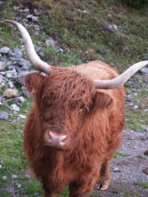
I am in Germany for the first time. I consider it a perfect opportunity to take a few days off and see the Alps. Everyone else just wants to get back home. I came with only vague plans about what to do. I have been asking everyone where to go, what to do. I am surprised that I cannot find any useful information. No one I talk to does that kind of thing, or even knows anyone who can give me advice. The only solid information I get is that people in Switzerland all eat an exotic delicacy “kaiserschmarrn.” I am advised to try some if I can.
So, lacking any better ideas, I plan to go to Innsbruck, which I gather is the tourist capitol of the Alps. At least my daughter recommends it. I am told to arrive at the train station 30 minutes before departure, because I need to buy a ticket. I am already ten minutes behind schedule, and I have trouble locating the ticket office. The line moves slowly, but I finally get my ticket. When I look at it, it does not say what track the train is on. When I look up at the schedule board, I cannot find my train. I don’t even know what to look for. Maybe this number here is the track number. I go to the track and get on the train. I ask a passenger, “Innsbruck?” They shake their heads “No” and I scurry off. The train pulls away seconds later.
So now I ask the station officials, who point me to other station officials, who eventually give me a track number and say “three minutes.” Whoa! I hurry over and get on the train, relieved. I ask a passenger “Innsbruck” and again heads shake “No.” Off again, I ask another agent, and she says “next train, one minute” as the one I just jumped off quietly glides away. Sure enough, one minute later, another train pulls up and it says “Innsbruck” on the side.
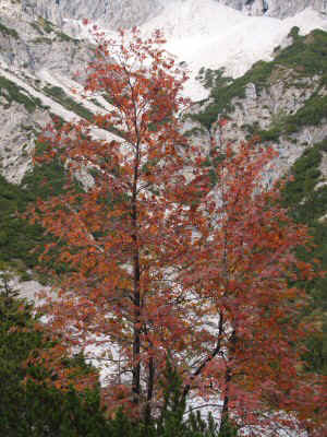
This train has passenger compartments, with a door and everything, as well as regular seats. I thought those compartments were only in old movies. I take a compartment, which I initially share with one other passenger. Later a few more got on, then off. No one speaks the whole time. We pass lots of pretty farmland and villages. The weather alternates between light rain, clouds, and sunlight. Everything is very green and beautiful. We pass through Stuttgart, then Munich, where almost everyone gets off. As we leave the station, I am joined in the compartment by a woman about my age. I figure unless I say something first, it will be another hour of silence. I ask where she is going, and that broke the ice. She is very friendly and we talk all the way to Innsbruck. I got to hear about Austrian politics, history, geography, etc. She is returning home to Innsbruck from a day in Munich, celebrating Octoberfest with her friends. Apparently Octoberfest is a Munich thing only.
|
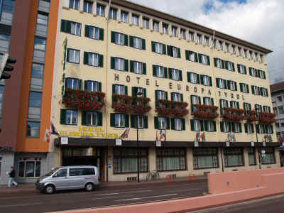
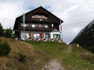
I asked for hiking advice, but even though she was born and raised in Innsbruck, she was not a hiker. She insists that I stay at the Hotel Europa, and walks me there from the train station. I was grateful for this, since by now it was quite late at night. She spoke to the front desk a long time in German, and they nodded and said they would take care of me and find me a mountain guide the next morning. As we said goodbye, I realized I did not even know her name. The Hotel Europa was the perfect place – near the center of town, delightfully quaint, and very helpful. The whole time there, I did not hear any other guests speaking English, but the staff was quite fluent. They all dressed up in Tyrolean garb, very cute. The next day I discovered that everyone else in Innsbruck dressed in normal clothing. |
|
| Hotel Europa Innsbruck |
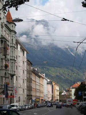
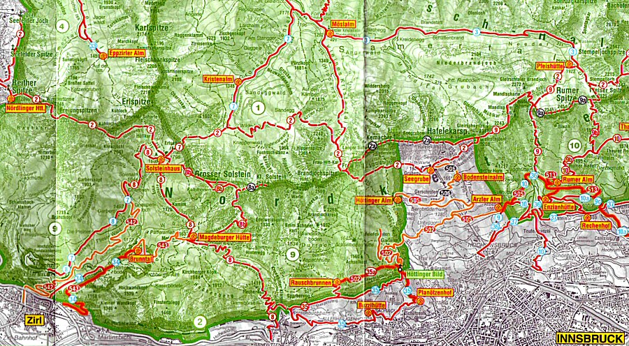
First thing the next morning I go to check out the town. I see hiking and camping stores on every street. I find the tourist information center, but they are not very helpful. They say I need to go back to the hotel and get a signed “Innsbruck” card. On the way back to the hotel, I pass the office of the alpine club, and stopp in. When I said I was thinking of hiking from hut to hut, the guy there was very interested. But when I showed him the hike I wanted to do, he shook his head, said “too cold, huts closed”. Instead he suggested a hike much closer to town, in Alpenpark Karvendel. He marked three huts, described how long each day’s hike would be, and even told me how to catch the train to the trailhead. The plan was to hike up to Solsteinhaus the first day (a three hour hike), then over Frau Hitt Pass to Pfeischutte the second day (lots of up and down) and to Bettelwurfhutte the third day. From there I could climb Bettelwurf peak, then hike back down and take a bus back to Innsbruck. He scoffed the “Innsbruck Card” and said that was for people staying in town. |
|
|
| Downtown Innsbruck |
|
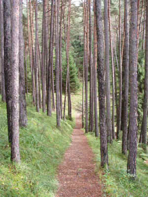
I stopped by a sporting goods store to get a pair of gloves and a map, and then went back to the hotel to pack up. The hotel kindly agreed to keep my baggage until my return in three days. When I bought the train ticket, I was surprised that it was only two euros. It must be really close by. The train quickly ascended up the side of the valley, snaking in and out of tunnels. My stop at Hochzirl came quickly, and I almost did not make it out in time. It was a tiny platform, high above the town of Zirl, where there with no one in sight. I followed a little sign pointing to the trail, heading into the forest. |
|
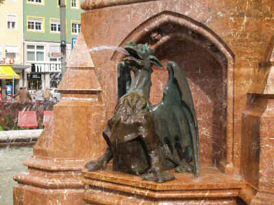
| Innsbruck Fountain |
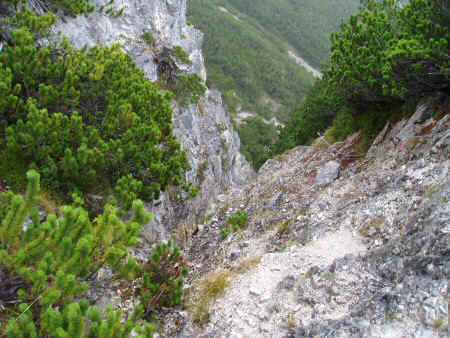
I followed the trail a while, through lush green forests, quickly leaving the railway below. After a few switchbacks it joined a road. I could not tell if the trail crossed the road, or followed it, so followed the road. Apparently that was correct, but an uncertainty about the trails was to remain a constant state of affairs this whole trip. The map I bought turned out to be for farther east, covering the second half of the trip only. Well, I thought, at least I have the little map from the alpine society. I had asked if the first day’s hike was steep, because it looked like the trail went from the valley floor to high in the mountains. The guy at the alpine society said “no, it was not steep, but the next day, yes, very steep.” But this trail, even the part on the road, was about as steep as any trail I had been on. Ignoring switchbacks, it just went right up the side of the mountain. As I passed a cable lift that disappeared up into the clouds, the road ended, and the trail became even steeper. |
|
|
| Trail, near train station |
|
But now it was a trail, passing through forests, meadows, and bands of rock. It skirted the bottom of spectacular cliffs, soaring up to a high ridge way above. It looked impossibly high. I was hoping the trail was headed for a pass, not this ridge. | |
| Along the trail |
| The trail passed a number of private mountain houses – little one-room buildings perched on tiny meadows on the ridge. None seemed to be occupied. The trail forked, which was a surprise because my map did not show another trail joining the one I was on. At least not until I looked really closely, and then I noticed that in addition to the red trails, there were a whole network of almost imperceptible green trails (on a green background) gong all different places. I stayed on what looked like the main trail, and eventually it lead to my day’s goal, Solsteinhaus hut. The hut looked like a Disneyland Swiss chalet, with a stone lower floor, balconies on the wooden upper floors, and a steeply pitched roof. t |
|
|
| Solsteinhaus |
|
I had made good time, starting at 12:30 and arriving at 3:00, beating the suggested time of 3 hours. All the signs and guides give the time, not the distance, between points on the trail. I thought this was strange, because people hike different speeds. Even stranger, the time is often the same going up and down the same trail. Later I realized that there are very (very) few trails that are level – most go steeply up or down (or both). They are so steep that distance really has no meaning, and going down is as much work (and about the same speed) as going up. So it makes sense after all. I arrived before most of the other guests. I set my boots on a shelf, and exchanged them for a pair of Birkenstock sandals that people wear inside. I signed up for a “bed” and a “mountaineer’s dinner.” Everything, including breakfast, was 31 euros. I think the other option was a dorm-style bedroom, but I never did figure it out (it was cheaper). My bed consisted of a mattress, pillow, and two blankets, in a small room with 6 beds. It was cold – the only room with heat was the kitchen-dining room. I explored around the area for a while, but it was raining and cold, so I returned to the hut to warm up. Apparently all huts have a central wood stove, made out of distinctive ceramic blocks, in the center of the dining area. As I sat warming up, people arrived steadily, in bunches. Most were my age or older. One group of about a dozen looked hearty, weather beaten, and in good spirits. They brought to mind the Elks club. They all assembled in an adjoining dining room, where they sang, laughed, yodeled, and lived it up. The staff brought in a round of beers, then several bottles of wine, then a round of schnapps, the more beers. Every time the door opened, the sound of the celebration would spill out into the main dining room. |
|
| Meadow near Solsteinhaus |
The rest of us were a group of six middle aged men, a group of four in their thirties, a man and woman in their 60s, and me. The group of six played some kind of game that looked like a cross between dominos and rummy – played with hundreds of cardboard squares with handwritten numbers on them, putting them in different configurations and piles. There were frequent groans, sighs, and cheering as pieces were played. After the game was over, they pulled a book off the shelf and took turns reading stories aloud to each other. Later I looked at the book, and it was a book of “hut tales” – stories, poems, songs, etc for mountain hut visitors. The group of four played a few board games, and then read stuff from the hut bookshelf. Mountaineers dinner consisted of three courses: salad (lettuce, grated carrots, grated cabbage, tomato, with salad dressing), wienerschnitzel, and desert. Wienerschnitzel is a thin slice of pork (not ham) breaded and crisply fried. Almost like fried chicken. It was served with potatoes and vegetables. Desert was a round pastry, with custard in the center, very light and fluffy, broiled so it has a crust outside, but still cool inside. Very tasty. No one else ate more than half their dinner or desert. I cannot understand why – I thought it was all delicious. As soon as it was dark, I went up to bed. I started with my down jacket, pants, everything. I did not believe I could be warm with just two blankets. But after a while I took off the jacket, then the pants. Boy – these are warm blankets. The thermometer inside the front door had read 5 (Celsius) in the afternoon, and it was colder at night. Nevertheless, I was plenty warm. The signs in the dining room seemed to lay out many rules, which I never could decipher. I think one of tem was “In bed by9:45; lights out 10:00.” Indeed, by 10 it was dark and quiet. Anyone moving around (going to the bathroom) after that was using a headlamp or flashlight. |
|
|
| Dinner at Solsteinhaus |
|
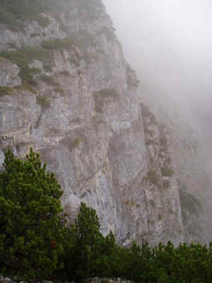
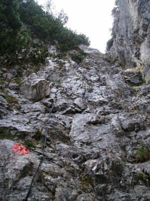
The next morning, breakfast was from 7 to 8. I was the first one up, at 7. Everyone else seemed to be sleeping in, shaving, whatever. Breakfast was bountiful: bread and butter, jelly, nutella, honey, big pots of museli, corn flakes, fruit salad, and yogurt, and big piles of sliced meat and cheese. Several of the people took a bowl of corn flakes, added fruit salad, then yogurt on top of everything. The bread was always some form of rye – dense and flavorful. After I finished, I sat by the stove to warm up as everyone else came and ate. Everyone still seemed to be in high spirits. It was still raining lightly, and I was just a little apprehensive about the day’s walk. The trail was visible across the valley, heading around and then up the opposite wall. I had been able to see it for the last hour yesterday. Although I had looked and looked at the map, I did not realize that the trail I wanted went around the mountain the other way. The signs were confusing, and I simply failed to pull out my map ad consult it at the critical junction, so I headed off in the wrong direction. The trail ascended for 30 minutes, then took a breathtaking plunge 600 feet straight down a sheer rock face. There was a tiny crack, and a steel cable bolted to the rock face. As I headed down, I could not even see the bottom – it just got steeper and steeper. Of course everything was wet in the rain. So this is what they meant by steep! t |
|
| Trail to Magdenburger Hutte |
I finally got down, and found myself on a series of tiny ledges strung together into a trail. There were cliffs stretching into the mist above and below. Just a cable and a tiny little path carved into the rock face. This nerve-wracking affair went on for another 30 minutes until the slope gradually because less steep. A little while later I arrived at a hut, and realized that I was on the wrong trail! My heart sank – two hours in the wrong direction. I could not stomach the thought of going back up that cliff. I looked at the map a lot more closely now. I could hike back down to the train station, or take a series of “green” trails around this side of the mountain to meet the trail I was supposed to be on. I decided on the latter, cursing myself because I was missing the more scenic route. First, I miss the high country altogether because of the late season, then I miss the high part of the low country because of a wrong turn. |
|
|
| Near Magdenburger Hutte |
|
These green trails were a lot harder to follow, especially because there were no trail signs whatsoever. Trails were very indistinct, and what looked like a side trail would often peter out in a few minutes. I kept going, following the strongest trail around the mountain, but again I was heading for cliffs, and I did not know how this trail could possibly go around them. The path kept getting fainter and fainter, and I spent more and more time scouting around, until I could progress no farther. The only path seemed to lead straight down the slope, toward Zirl, which was clearly visible below. So I gave up, and headed down the slope, following occasional red paint marks down the incredibly steep slopes. I want almost all the way down, far enough that I could clearly see buildings, cars, even people in the town below. But it seemed to be nothing but cliffs between me and the town. The red marks disappeared. I searched and searched from the last one, without success. I walked back and forth above the cliffs, but I could find no way down. After an hour of searching, I reluctantly decided I had to go back. | |
| This is what blocked my way |
| First challenge – find the red marks again. Then I climbed up and up and up – as steep as a rocky slope can be. Finally I found the red marks, then climbed up to the path, then retraced my steps. Actually, I got lost several more times because the path was so confusing and indistinct. I finally just headed down toward a road I could see, and then hiked about 30 minutes back up to the road to the hut I had passed that morning. Six hours of exhausting climbing: was ready to stop.t |
|
|
| Above Zirl |
|
I went in the hut and arranged to stay over, and had a hot chocolate. A few parties came, ate, and departed. This hut did not seem to be as friendly as the one last night. At 4:30 I decided maybe if I hurried I could make it back to Solsteinhaus before dark. It was raining steadily, but I was determined. . | |
| I saw lots of these |
| I hurried back along the cliffs, now thinking only of the climb to come. When I did get to the 600 foot vertical cliff with
the cable, I hurried up with all the energy adrenaline can supply. When I got to what I thought was half way, I was
actually at the top. Compared to this morning,
this now seemed like a piece of cake. After a slippery slog to the Solsteinhaus, I announced “I’m back.” The staff was surprised to see me. I was unable to describe where I had been all day. They gave me another room, and this time mountaineer’s diner was spaghetti. I drank another hot chocolate, a Pepsi, a big glass of water, and was still thirsty. The visitors this night were a different crowd. There were five young couples in several parties, one with three young children, two with dogs. There were some older couples, some groups of four, and a white haired gentleman alone like myself. We tried several times to communicate, but he knew no English and I knew no German. He did chat with everyone else. He pulled out a can of sticks and some carving knives, and carved flowers for the children. He was really good at it. Everyone (but me and the children and the dogs) had a beer as soon as they arrived. The beer was large – twice as large as a Pepsi and less expensive. Even schnapps was less than a Pepsi. I never saw anyone else drinking water, soft drinks, hot chocolate, anything non-alcoholic. |
|
|
| Back up the cable route |
I did not have much time to worry about the next day’s hike – I was so tired I fell asleep at 7:00 PM and slept soundly until 7:00 the next morning. The temperature had fallen, and the rain was now steady. The alpine society had warned me that the Sunday weather was going to be poor. How bad could it be? I felt remarkably well rested and recovered from the previous day’s ups and downs.
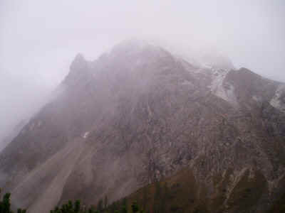
This time I resolved to keep a closer eye on the map, as I headed off into the rain. The trail descended steeply down, until it forked and headed back up just as steeply. Everything was shrouded in clouds, so it was generally impossible to see the tops of the peaks all around. But what I could see was unbelievably steep. I was heading into a dead-end canyon! I would just have to trust the trail, and hope that there was nothing worse than yesterday.
As I climbed, the rain turned to real snow. The trail rounded a shoulder, and turned away from the cliffs into a side valley. It passed over a saddle, and then contoured along the side of the valley, with the valley floor falling steeply away. Although it was still snowing steadily, my hopes were buoyed by this rare section of level trail, where I could make quick progress. Well, that did not last long.
|
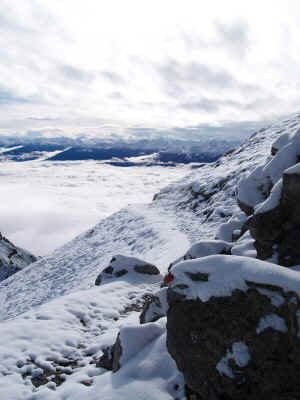
The trail came to a big rock face, and took a sharp turn down, straight down, a little scree chute plunging toward the valley floor. Then suddenly, I cam to an unmarked junction. There are no junctions on the map! How could this be? I took a guess, heading right instead of down. Ten minutes later I came to another junction, this one with a sign. Still no junction on the map, but I know I am supposed to be heading toward Frau Hitt Sattel, which is one of the directions on the sign. So the trail goes up some more. As I gain altitude, I pass the tree line, the snow starts to cover the ground, and still the peaks are above me and out of sight behind the clouds. I am entering a bowl, with cliffs all around, and with the trail increasingly hidden under the snow. Oh well, I will keep following it for as long as possible, and then turn around if necessary. The trail seems to be heading up a rocky cute, the only break in the cliffs. I still cannot see the top, so I don’t know if it ends in another climb up a cable. Only this time, everything is covered with ice. I can see some jagged teeth up above, but I dare not hope that they are the top. Beyond this, I can see only white. It really does not look like sky. They are so close, but everything is so steep, the trail has disappeared, I am crawling up on all fours, slipping back half a step for every step I take. It seems to take forever to get to the biggest tooth. As I reach it, I can see beyond, the other side of the ridge. I have made it! The other side, however, is even steeper. No chute – only a vertical cliff going down into the mist. The map shows a junction at the pass, with one route going left up the ridge and another across and down the other side. I straddle the ridge, looking for some hint of a trail down. Finally I spy a cable heading right along the ridge. I kick the ice off the rocks, hang onto the cable for dear life, and inch along the ridge until I reach another saddle. This one has a trail crossing and down the other side! It is still a vertical cliff, with a narrow, snow covered, slippery path cut into it, with no cable to hold onto. I figured I would trust the trail builders, and the sooner I got down the better. I thought at the time of taking a few pictures, but I all I could concentrate on was going forward. The trail descended to the base of the highest cliffs, then angled down across what seemed like miles of very steep slopes. The trail was relatively level, but one slip would send me plunging down who knows how far, so I could not enjoy it. The scenery was limited to a few feet in front and behind. At this point, the trail builders really outdid themselves, with junction after junction. Some had signs, naming places that do not appear on my skimpy map (which is now wet and disintegrating). Some have no signs at all. Each time I am left to guess. It would be easier if I had some landmarks I could head toward, but nothing is visible in the clouds. |
|
| Climbing into the clouds |
Finally, out of the mist above, appears a tower – a weather station. A minute later, I see a ski lift. I am at Seegrube! All the structures I can see are deserted – they must be for winter sports. I can hear a fan off in the distance, so I follow the sound. It is the top of the gondola lift. I enter the snack bar, which is deserted except for the staff. I have a hot chocolate and try to warm up. I have been telling myself for the last few hours that I can stop here, this is my goal. Clearly the original goal, Pfeichutte, a few hours farther up the trail, is out of the question. But I just can’t make myself stay. There is a trail hut another 45 minutes down the trail, which might be more appealing, so I bundle up, put on my soaking gloves and hat, and head out into the blowing sleet. The sign says to head west, which seems wrong, but I follow it. The next sign says to head north, which also seems wrong, but I follow it. The next sign says to head east, which seems right, but I have now just spent the last ten minutes making ¾ of a circle around the extensive winter sports area. Still, I am reluctant to ignore the signs and head off on my own. So this last sign was right and the trail heads down as it should. The snow turns to rain, the trail turns to mud, but is still very steep, so I continually slip and land on my butt in the mud. What a relief to spy the hut. It looks so picturesque, just what I was hoping for. I enter to find five people gathered in the main room singing. They insist that I stand in the middle of the room while they serenade me. I am dripping wet, but no matter. They pass the guitar around, each one leading a song or two. Everyone seems to know these songs. One features a whole verse of yodeling, another has a little yodel only for the leader, a third features “Innsbruck” twice in the refrain. Finally I ask if I can stay for the night, and everyone frowns and says of course not. I never found out is this is only a eating and gathering spot, or if the overnight season is over, or what. They all tell me “Hottlinger Alm, one hour, west.” Since it is getting late, I hurry on. |
|
|
| Bodensteinalm |
Unfortunately there seems to only be a trail down, not west. By now I am reluctant to go anywhere off the marked trail. The slope is still extremely steep, with no bottom in sight. My map says if I go down, then I will reach a junction that will allow me to go to Hottlinger. A lot further down, I do indeed reach a road, and it goes west and UP. I can either bag it now and descend the rest of the way to town, or climb back up. I decide to go back up, with the plan to turn around if I do not find the hut by dark. Just as that deadline approaches, I see the hut emerging from the mist across a ravine. A few minutes later, and I am there. It is a nice looking hut, but there is no one else around but two staff. They agree to let me stay, and to feed me. I have spinach knodel (dumplings) that are quite good. As I eat, another couple arrives, orders diner, eats in silence, and leaves. I finally ask after my room, which is in a separate building, even more primitive than Solsteinhaus. It is colder here, and absolutely no heat, but everything I have is wet, so I take it all off, hang it up, and borrow blankets from several other beds to huddle beneath. It does not take long to warm up and fall asleep.
|
After another 12 hours of sound sleep, I suddenly realize it is 7:15, and I had told the staff I would have breakfast at 7:00. I hurry to put on my wet clothing and head over to breakfast. This time, the minimum – bread, meat, cheese. I ask for milk to drink. They are startled I did not want beer, but bring me milk anyway. The morning looks like it clear at the higher elevations, although it is cloudy down below. I decide I will hike down to the gondola, and ride up to the top. I can then see the sights and perhaps even head toward yesterday’s intended destination, Pheischutte. |
|
| Near Hottlinger Alm |
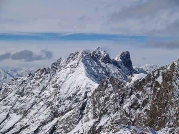
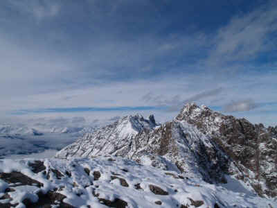
The gondola ride was spectacular, emerging from the clouds into the sun, and then up into the snow. At the top, everything was covered in a few inches of new powder. No one was riding up with me; it appears no one has ridden up yet today. There are no footsteps in the snow out the door. There is a sign for Pfeischutte trail, but with the snow cover it is hard to follow it. Eventually the trail becomes a narrow ledge in a steep cliff. Now that I can see how far down the cliff goes I am scared. The trail is icy under the snow, very slippery, and there begin to be gaps in the ledge that I need to step (then jump) over. I see the trail up ahead, snaking along the cliffs below. My nerves cannot take it – I have to turn back. I spend an hour on top of the ridge, taking in the scenery. Everything up here is sparkling in the snow and the sun. The mountains all around are so pointy, so steep. It is impossibly jagged. I try to make sure I remember this moment. |
|
|
| Frau Hitt Sattel |
|
When I return to the gondola, there is still no one else there. Maybe I will be the only passenger today. The ride back down into the clouds is eerie. I catch the bus back to Innsbruck, and return to the hotel. |
|
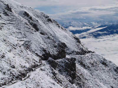
| Route to Pfeischutte |
| Later I return to the alpine club, to talk to the advisor again. I tell him I had a great time, despite the weather. I don’t mention I took a wrong turn. I ask him about the crowds, then the empty hut. He says, yes, the huts would be busy on Friday and Saturday, deserted on Sunday. They are all closing this very day. I was there on the last day of the season. Everyone wanted to go up one last time this weekend. Other questions – I ask why I saw no one else on the route from Solsteinhaus to Seegrube, across Frau Hutt Sattel. He says it is too extreme – only 20 people a week cross in the peak season, in August. No one in their right mind would cross it in the snow. OK. Then where did all the people at Solsteinhaus come from? Everyone came up the way I did, from Hochzirl, and goes back down the same way. What about everyone’s huge pack and fearsome mountaineering boots (I had the puniest gear in the whole hut)? Its just ego – no camping allowed, so all those people carrying tents and sleeping bags are doing it just for show. Where can I buy that funky gear (the wool sweaters, the hiking knickers, etc.? I don’t see them in the stores in town. Answer: “Forget it, no one but crazy Germans buys that. You can’t get that in Innsbruck. Go for fleece, nylon, and polypropylene. That other stuff is just history, like in museums.” I also find out that the huts are booked solid a month in advance in the summer (June, July, August), that you have to make reservations with each one individually (no common booking agency) and that there is no English language book, pamphlet, or website listing hut information. I guess it is for insiders only. |
|
|
| Trail to Pfeischutte |
|
Well, I can’t wait to go again, this time better prepared. I will be sure I have the right maps, will read them without fail, and will have everything booked well in advance. I will start early, so I will have plenty of time to get where I am heading. Next time. |
|
| Trail to Pfeischutte |
cchayden@gmail.com